STORM WATCH: Wet start to the week; hazy sunshine returns midweek
Keep the umbrella with you through midday Tuesday! More summer-like and drier weather moves in starting Tuesday afternoon.
Share:
More Stories
2:18

Wet start to the week in the Hudson Valley; sunshine returns midweek
13h ago1:16
Streak of weekends with rain set to continue for lower Hudson Valley
5ds ago2:18

Sunny and clear Monday in the Hudson Valley before temps soar later this week
7ds ago2:18

Memorial Day weekend ends with beautiful evening in the Hudson Valley
13ds ago
News 12 weather blog
23ds ago2:18

Sunny and pleasant Monday in Hudson Valley; more rain chances this week
28ds ago2:18
Wet start to the week in the Hudson Valley; sunshine returns midweek
13h ago1:16
Streak of weekends with rain set to continue for lower Hudson Valley
5ds ago2:18
Sunny and clear Monday in the Hudson Valley before temps soar later this week
7ds ago2:18
Memorial Day weekend ends with beautiful evening in the Hudson Valley
13ds agoNews 12 weather blog
23ds ago2:18
Sunny and pleasant Monday in Hudson Valley; more rain chances this week
28ds agoIt is going to be another up-and-down week of weather across the lower Hudson Valley. Today is just a gloomy day with off and on light rain showers.

Tomorrow morning will be impacted by a quick, but heavy at times, round of rain. A rumble of thunder is possible tomorrow morning along with slower than usual travel for the morning commute.

Tomorrow afternoon will be much better and then the rest of the week will be nicer overall. You will likely notice a little bit of haze moving back tomorrow evening. This is from Canadian wildfire smoke again and can linger through at least Thursday. At this time, it is not expected to dramatically impact air quality, but the News 12 Storm Watch Team will monitor this for you through the week.

It also becomes much warmer for Wednesday through Friday with high temperatures back in the 80s along with moderate humidity for Thursday and Friday.
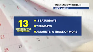
The streak of weekends with some sort of rain looks like it will continue this weekend unfortunately, too. Scattered rain is likely on Saturday with an isolated shower on Father's Day.
Have a great Monday!
FORECAST:
TODAY: SCATTERED SHOWERS — Cloudy and cool with scattered, mostly light, rain showers. Highs around 65 degrees.

TONIGHT: Cloudy with patchy fog and spotty drizzle. Lows near 60 degrees.

TUESDAY: STORM WATCH (AM) — Cloudy with periods of moderate to heavy rain in the morning. An embedded thunderstorm is possible, but severe weather is not expected. That said, travel will be slowed for a few hours during the morning. Rain totals will be around or slightly less than one inch. The afternoon is better with breaks of sun developing and only a spotty passing shower. Highs around 75 degrees. Lows near 61 degrees.


WEDNESDAY: HAZY SUNSHINE -- Mostly sunny to partly cloudy. The sky will likely be a bit hazy due to Canadian wildfire smoke in the upper atmosphere again. Air quality will be monitored but is expected to be good to moderate at this time. More summer-like! Much warmer with highs around 83 degrees, but the humidity will be fairly low.
THURSDAY: HAZY SUN AND CLOUDS — A summer feel with a mix of sun and clouds with a hazy sky likely again. Very warm to hot and noticeably humid with high temperatures around 87 degrees. Lows near 65 degrees.
FRIDAY: SPOTTY SHOWER — A mix of sun and clouds with a pop-up afternoon or evening shower possible. Highs around 84 degrees. Lows near 62 degrees.
SATURDAY: OFF AND ON RAIN — Unfortunately, it looks like another weekend will be impacted by some rain! It does not look like washout territory yet, but at least scattered showers and an isolated thunderstorm cannot be ruled out. Highs around 74 degrees. Lows around 60 degrees.
SUNDAY: FATHER'S DAY — Mostly cloudy to partly sunny with an isolated shower. Most of the day should be dry. Highs around 72 degrees. Lows near 57 degrees.

More from News 12
2:18
Wet start to the week in the Hudson Valley; sunshine returns midweek
2:18
Sunny and clear Monday in the Hudson Valley before temps soar later this week
2:18
Memorial Day weekend ends with beautiful evening in the Hudson Valley
News 12 weather blog
2:18
Sunny and pleasant Monday in Hudson Valley; more rain chances this week
2:18
